
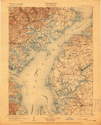
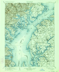
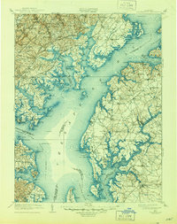
1908 Map of Tolchester
USGS Topo · Published 1908About this map
The Chesapeake Bay dominates this early twentieth-century survey, revealing a landscape defined by its intricate shoreline and maritime defense network. At the mouth of the Patapsco River, Fort Howard and Fort Smallwood stand as key sentinels alongside the Sevenfoot Knoll LH. Inland, the settlement pattern follows the established rail corridors of the Philadelphia Wilmington and Baltimore RR and the Baltimore and Ohio RR, which connect industrial hubs like Harford Furnace to larger towns such as Chestertown and Centerville. The map provides a detailed view of the Eastern Shore's river systems, including the Chester River and Sassafras River, where long-standing agricultural districts like Worton and Fairlee were already well-settled. From the upper reaches of Gunpowder Falls to the isolated stretches of Spesutie Island, the map captures the transition from bustling railroad towns to quiet tidewater landings.
Find a feature on this map
248 named features on this map. Tap any name to fly to it.
Don’t see what you’re looking for? This feature index may not catch every label — zoom into the map to look around manually.
Map Details
Editions of this 1908 Tolchester Map
4 editions found
Other maps of this area

1892 · Owensville
USGS Topo · 1:62,500

1892 · Annapolis
USGS Topo · 1:62,500

1893 · North Point
USGS Topo · 1:62,500

1893 · Gunpowder
USGS Topo · 1:62,500

1894 · Baltimore
USGS Topo · 1:62,500

1894 · Relay
USGS Topo · 1:62,500

1895 · Owensville
USGS Topo · 1:62,500

1898 · Choptank
USGS Topo · 1:125,000

1898 · Elkton
USGS Topo · 1:62,500

1898 · Tolchester
USGS Topo · 1:125,000