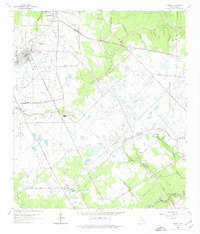
1962 Map of Tomball
USGS Topo · Published 1974About this map
The Hufsimth Oil Field and the Southeast Tomball Oil Field define the industrial character of this landscape in the early 1960s, a period when rural Harris County was becoming increasingly crisscrossed by petroleum infrastructure. Petroleum development is seen here in a dense network of pipelines and pumping stations that run alongside established family farms and early German settlements like Klein and Kohrville. The transit of the Chicago Rock Island and Pacific railroad through Tomball highlights the area's role as a regional hub for both freight and local commerce.
Find a feature on this map
46 named features on this map. Tap any name to fly to it.
Don’t see what you’re looking for? This feature index may not catch every label — zoom into the map to look around manually.
Map Details
Editions of this 1962 Tomball Map
4 editions found
Other maps of this area

1915 · Cypress
USGS Topo · 1:24,000

1916 · Rose Hill
USGS Topo · 1:24,000

1916 · Aldine
USGS Topo · 1:24,000

1916 · Louetta
USGS Topo · 1:24,000

1916 · Satsuma
USGS Topo · 1:24,000

1916 · Spring
USGS Topo · 1:24,000

1918 · Cypress
USGS Topo · 1:31,680

1919 · Aldine
USGS Topo · 1:31,680

1920 · Spring
USGS Topo · 1:31,680

1920 · Rose Hill
USGS Topo · 1:31,680