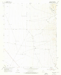
1952 Map of Tome SE
USGS Topo · Published 1976About this map
The eastern slopes of the Manzano Mountains dominate this 1952 topographic study, revealing the complex intersection of land grant boundaries in Valencia County. The map provides a detailed view of the Belen Grant, Tome Grant, and Casa Colorada Grant, illustrating how historical land divisions dictated the management of this arid terrain. This high-altitude landscape is part of the Cibola National Forest, where water management is critical for survival and land use. Isolated water sources like North Well, Mountain Well, and the 8 Windmill are meticulously recorded, alongside a notable Levee system. These features represent the infrastructure necessary to support ranching and resource management within the expansive grants and forest lands during the mid-twentieth century.
Find a feature on this map
13 named features on this map. Tap any name to fly to it.
Don’t see what you’re looking for? This feature index may not catch every label — zoom into the map to look around manually.
Map Details
Editions of this 1952 Tome SE Map
4 editions found
Other maps of this area

1916 · La Joya
USGS Topo · 1:125,000

1917 · Estancia
USGS Topo · 1:125,000

1952 · Tome SE
USGS Topo · 1:24,000

1952 · Black Butte
USGS Topo · 1:24,000

1952 · Tome NE
USGS Topo · 1:24,000

1952 · Turn
USGS Topo · 1:24,000

1952 · Tome
USGS Topo · 1:24,000

1952 · Becker
USGS Topo · 1:24,000

1954 · Capilla Peak
USGS Topo · 1:24,000

1954 · Torreon
USGS Topo · 1:62,500