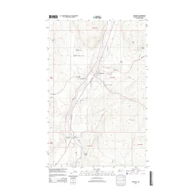
2014 Map of Tonasket
USGS Topo · Published 2014About this map
Tonasket serves as the central hub of this northern Washington landscape, situated along the banks of the Okanogan River. The river valley acts as a critical corridor for both transport and industry, evidenced by the presence of both the Tonasket Municipal Airport and the smaller Whitestone Airport. To the south, the settlement of Janis marks a key crossing point where the Janis Bridge spans the water near the Janis Rapids. The terrain is defined by dramatic geological features such as Whitestone Coulee, Wagonroad Coulee, and the steep walls of McLoughlin Canyon. Upland areas like Horse Mtn and Duffys Mtn overlook the Antoine Valley, while small water bodies like Perry Lake are tucked into the higher elevations. This map illustrates the transition from the river-bottom agricultural and municipal areas to the more complex, canyon-cut highlands of Okanogan County.
Find a feature on this map
52 named features on this map. Tap any name to fly to it.
Don’t see what you’re looking for? This feature index may not catch every label — zoom into the map to look around manually.
Map Details
Editions of this 2014 Tonasket Map
This is the sole edition of this map. No revisions or reprints were ever made.
Other maps of this area

1902 · Osoyoos
USGS Topo · 1:125,000

1904 · Osoyoos
USGS Topo · 1:125,000

1906 · Chopaka
USGS Topo · 1:125,000

1954 · Okanogan
USGS Topo · 1:250,000

1956 · Loomis
USGS Topo · 1:62,500

1957 · Conconully
USGS Topo · 1:62,500

1957 · Tonasket
USGS Topo · 1:62,500

1957 · Oroville
USGS Topo · 1:62,500

1958 · Okanogan
USGS Topo · 1:250,000
1980 · Keystone
USGS Topo · 1:24,000