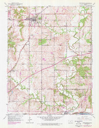
1950 Map of Tonganoxie
USGS Topo · Published 1978About this map
Tonganoxie serves as the primary hub of activity in this 1950s Kansas landscape, situated near the headwaters of Tonganoxie Creek. The rural topography is defined by a dense network of one-room schoolhouses, such as Honey Valley Sch, Hawk Hollow Sch, and Walnut Sch, which highlight the decentralized agricultural community of the mid-twentieth century. Transportation infrastructure is well-represented by the Union Pacific railroad corridor and the Kansas Turnpike, which cuts across the central portion of the quadrangle. In the south, the Kansas River forms a natural boundary near the settlement of Linwood, where the Mt Sidney Cem and several other family or community burial grounds like Sarcoxie Cem are located. The map documents the region's transition, with older rural school districts still clearly marked alongside newer infrastructure, providing a detailed view of Leavenworth Co as it appeared before significant suburban expansion.
Find a feature on this map
32 named features on this map. Tap any name to fly to it.
Don’t see what you’re looking for? This feature index may not catch every label — zoom into the map to look around manually.
Map Details
Editions of this 1950 Tonganoxie Map
2 editions found
Other maps of this area

1885 · Lawrence
USGS Topo · 1:125,000

1886 · Oskaloosa
USGS Topo · 1:125,000

1887 · Olathe
USGS Topo · 1:125,000

1888 · Oskaloosa
USGS Topo · 1:125,000

1889 · Lawrence
USGS Topo · 1:125,000

1890 · Kansas City
USGS Topo · 1:125,000

1893 · Olathe
USGS Topo · 1:125,000

1894 · Kansas City
USGS Topo · 1:125,000

1894 · Oskaloosa
USGS Topo · 1:125,000

1934 · Bonner Springs
USGS Topo · 1:48,000