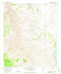
1964 Map of Tonto Basin
USGS Topo · Published 1965About this map
The high desert landscape of Tonto Basin is defined by the sharp contrast between the rugged Mazatzal Mountains and the life-giving waters of Tonto Creek. In the mid-1960s, the small settlement of Punkin Center serves as a primary hub for this ranching and forest region, featuring its own Punkin Center Landing Strip and a Tonto Basin PO. This map reveals a complex network of cattle ranching infrastructure, evidenced by numerous corrals and remote watering points like Packard Spring and Denton Trough Spring. Evidence of much older habitation is also preserved, with several sites marked as Ruins and Petroglyphs noted along the canyon walls. To the southeast, the rising waters of Theodore Roosevelt Lake create a distinct shoreline, while the higher elevations of the Tonto National Forest provide seasonal grazing in areas like Big Pine Flat.
Find a feature on this map
58 named features on this map. Tap any name to fly to it.
Don’t see what you’re looking for? This feature index may not catch every label — zoom into the map to look around manually.
Map Details
Editions of this 1964 Tonto Basin Map
2 editions found
Other maps of this area

1907 · Roosevelt
USGS Topo · 1:125,000

1909 · Four Peaks
USGS Topo · 1:125,000

1912 · Roosevelt
USGS Topo · 1:125,000

1954 · Mesa
USGS Topo · 1:250,000

1957 · Mesa
USGS Topo · 1:250,000

1958 · Mesa
USGS Topo · 1:250,000

1960 · Mesa
USGS Topo · 1:250,000
1963 · Mine Mountain
USGS Topo · 1:24,000

1964 · Mesa
USGS Topo · 1:250,000
1964 · Kayler Butte
USGS Topo · 1:24,000
Featured Places
- Tonto Basin, AZ
- Rancho Del Escondido, AZ
- Roosevelt Lake Gardens East, AZ
- Punkin Center, AZ
- Roosevelt Lake Gardens West, AZ