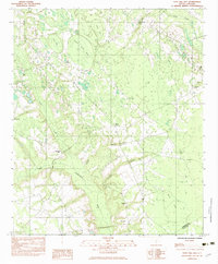
1982 Map of Tony Hill Bay
USGS Topo · Published 1983About this map
Tony Hill Bay and Bull Bay characterize this Lowcountry landscape in the early 1980s, where Carolina bays form distinct oval depressions across the coastal plain. The drainage network is defined by the Little Salkehatchie River and its tributaries, including Lemon Creek, Drawdy Branch, and Hurricane Branch. This era shows a community structured around small country churches and family burial grounds, providing significant data for genealogists. Numerous houses of worship, such as Hunters Chapel, Zion Ch, and Gethsemane Ch, are situated along the rural road network. The boundary between Bamberg County and Colleton County runs through the southern portion of the map, near the Carter Cem and Prospect Cem.
Find a feature on this map
23 named features on this map. Tap any name to fly to it.
Don’t see what you’re looking for? This feature index may not catch every label — zoom into the map to look around manually.
Map Details
Editions of this 1982 Tony Hill Bay Map
This is the sole edition of this map. No revisions or reprints were ever made.
Other maps of this area

1919 · Olar
USGS Topo · 1:62,500

1919 · Bamberg
USGS Topo · 1:48,000

1919 · Lodge
USGS Topo · 1:62,500

1920 · Lodge
USGS Topo · 1:48,000

1920 · Bamberg
USGS Topo · 1:62,500

1920 · Orangeburg
USGS Topo · 1:48,000

1921 · Orangeburg
USGS Topo · 1:62,500

1921 · Lodge
USGS Topo · 1:62,500

1943 · Olar
USGS Topo · 1:62,500

1943 · Lodge
USGS Topo · 1:62,500