
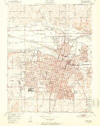
1951 Map of Topeka
USGS Topo · Published 1951About this map
The Kansas River divides this mid-century capital landscape, where the urban grid of Topeka expands rapidly into neighborhoods like Highland Park and Oakland. At the heart of the city, the State Capitol and Federal Bldg anchor a dense municipal core, while the sprawling campus of Washburn University and the Winter Veterans Hospital complex define the southwestern developments. The map reveals a high concentration of social and educational institutions, from the State School for Boys in the north to St Vincents Orphanage and the State Hospital.
Find a feature on this map
84 named features on this map. Tap any name to fly to it.
Don’t see what you’re looking for? This feature index may not catch every label — zoom into the map to look around manually.
Map Details
Editions of this 1951 Topeka Map
2 editions found
Other maps of this area

1889 · Burlingame
USGS Topo · 1:125,000

1889 · Topeka
USGS Topo · 1:125,000

1894 · Burlingame
USGS Topo · 1:125,000

1894 · Topeka
USGS Topo · 1:125,000

1947 · Lawrence
USGS Topo · 1:250,000

1950 · Kansas City
USGS Topo · 1:250,000

1950 · Lawrence
USGS Topo · 1:250,000

1950 · Topeka
USGS Topo · 1:24,000

1950 · Grantville
USGS Topo · 1:24,000

1951 · Grantville
USGS Topo · 1:24,000