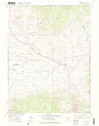
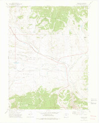
1972 Map of Toponas
USGS Topo · Published 1976About this map
The Denver and Rio Grande Western railroad tracks cut a decisive path through this high-country landscape, following the natural contours of Channing Creek toward the small settlement of Toponas. This 1972 survey captures a transition between the northern high-elevation timber of the Routt National Forest and the broad, open expanse of Egeria Park. The presence of the Landing Strip and numerous water management features like Stillwater Ditch and Five Pine Mesa Ditch indicates a localized economy dependent on both transportation and high-altitude irrigation. Distinctive landmarks such as Lone Spring Butte and Toponas Rock anchor the geography, while smaller family or place-named waters like Crowner Reservoir and Hadley Reservoir provide specific points of interest for those tracing local land use and development patterns in Routt County.
Find a feature on this map
30 named features on this map. Tap any name to fly to it.
Don’t see what you’re looking for? This feature index may not catch every label — zoom into the map to look around manually.
Map Details
Editions of this 1972 Toponas Map
3 editions found

Other maps of this area

1954 · Craig
USGS Topo · 1:250,000
1956 · Gore Pass
USGS Topo · 1:62,500

1957 · Craig
USGS Topo · 1:250,000

1957 · Leadville
USGS Topo · 1:250,000

1958 · Craig
USGS Topo · 1:250,000

1959 · Leadville
USGS Topo · 1:250,000

1960 · Leadville
USGS Topo · 1:250,000

1960 · Craig
USGS Topo · 1:250,000

1962 · Leadville
USGS Topo · 1:250,000

1962 · Craig
USGS Topo · 1:250,000