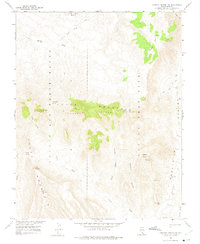
1961 Map of Topopah Spring NW
USGS Topo · Published 1975About this map
Nevada Test Site and Nellis Air Force Range dominate this desert landscape, as mapped in the early 1960s in cooperation with the Atomic Energy Commission. The topography is defined by the high, ridged spine of Yucca Mountain and the distinct volcanic features of Pinnacles Ridge. Navigating the arid basin are several named washes including Yucca Wash and Beatty Wash, alongside a series of canyons such as Black Glass Canyon and Paintbrush Canyon. Numerous survey points like VABM Yucca 6703 and VABM Leo 6195 provide precise elevations across the summits. To the east, Fortymile Canyon runs parallel to the Calico Hills, while the western edge is marked by the Beatty Trail and The Prow. This document captures the restricted geography of the high desert before it became a focal point of national environmental and nuclear debates.
Find a feature on this map
45 named features on this map. Tap any name to fly to it.
Don’t see what you’re looking for? This feature index may not catch every label — zoom into the map to look around manually.
Map Details
Editions of this 1961 Topopah Spring NW Map
3 editions found
Other maps of this area

1908 · Kawich
USGS Topo · 1:250,000

1908 · Furnace Creek
USGS Topo · 1:250,000

1910 · Furnace Creek
USGS Topo · 1:250,000

1942 · Tolicha Peak
USGS Topo · 1:125,000

1942 · Wheelbarrow Peak
USGS Topo · 1:125,000

1942 · Skull Mountain
USGS Topo · 1:125,000

1942 · Bullfrog
USGS Topo · 1:125,000

1948 · Death Valley
USGS Topo · 1:250,000

1952 · Topopah Spring
USGS Topo · 1:62,500

1952 · Timber Mountain
USGS Topo · 1:62,500