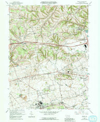
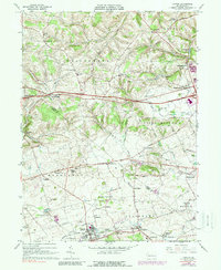
1965 Map of Topton
USGS Topo · Published 1992About this map
The borderlands of Lehigh and Berks counties during the mid-1960s reveal a landscape of long-established Pennsylvania Dutch farmsteads and growing village centers. Small rural hubs like Hynemansville, Seipstown, and Seiberlingville dot the northern hills, while the southern corridor through Topton and Mertztown shows the concentration of industry and rail infrastructure. Cultural anchors are prominent throughout the quadrangle, from the historic Ziegel Ch and St Pauls Ch to local educational sites like Township Sch and Weisenberg Sch. The map records a complex drainage network feeding into Iron Run and the Little Lehigh Creek, reflecting the natural hydrology that shaped early settlement patterns. Modern infrastructure, including a prominent Radio Facility and Sewage Disposal plant near Toad Creek, contrasts with older landmarks like the Quarry near Oreville and the winding course of Bullfrog Run.
Find a feature on this map
71 named features on this map. Tap any name to fly to it.
Don’t see what you’re looking for? This feature index may not catch every label — zoom into the map to look around manually.
Map Details
Editions of this 1965 Topton Map
5 editions found
Other maps of this area

1894 · Reading
USGS Topo · 1:62,500

1902 · Boyertown
USGS Topo · 1:62,500

1902 · Slatington
USGS Topo · 1:62,500

1909 · Hamburg
USGS Topo · 1:62,500

1911 · Hamburg
USGS Topo · 1:62,500

1913 · Reading
USGS Topo · 1:62,500

1915 · Reading
USGS Topo · 1:62,500

1937 · Allentown West
USGS Topo · 1:48,000

1942 · Allentown West
USGS Topo · 1:62,500

1943 · Manatawny
USGS Topo · 1:31,680