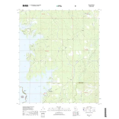
2018 Map of Toro
USGS Topo · Published 2018About this map
The expansive Toledo Bend Reservoir dominates the western landscape of this Sabine Parish study, where the waters of the Sabine River meet the border between Texas and Louisiana. This 2018 survey reveals a terrain defined by the complex interface of water and woodland, including portions of the Sabine National Forest and the northern reaches of the Fort Polk military reservation. Small settlements like Clare and Toro serve as focal points for a network of rural roads that navigate around numerous creek systems, including the prominent Bayou Toro and Wildcat Cr. Genealogists will find several burial sites preserved among the timberlands, such as Caney Cem, McMillion Cem, and Victoria Cem. The map provides a detailed view of contemporary land divisions, from the established Sabine and Vernon Parish lines to the residential developments along Lakeside Loop and Toro Bay Dr near the reservoir shoreline.
Find a feature on this map
92 named features on this map. Tap any name to fly to it.
Don’t see what you’re looking for? This feature index may not catch every label — zoom into the map to look around manually.
Map Details
Editions of this 2018 Toro Map
This is the sole edition of this map. No revisions or reprints were ever made.
Other maps of this area

1941 · Leesville
USGS Topo · 1:62,500

1942 · Florien
USGS Topo · 1:62,500

1943 · Leesville
USGS Topo · 1:62,500

1944 · Negreet
USGS Topo · 1:62,500

1944 · Wiergate
USGS Topo · 1:62,500

1944 · Florien
USGS Topo · 1:62,500

1946 · Leesville
USGS Topo · 1:62,500

1948 · Leesville
USGS Topo · 1:62,500

1948 · Wiergate
USGS Topo · 1:62,500

1953 · Alexandria
USGS Topo · 1:250,000