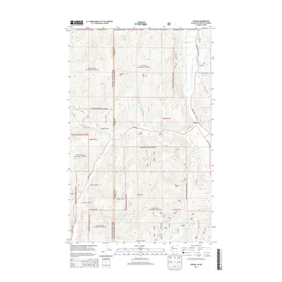
2014 Map of Toroda
USGS Topo · Published 2014About this map
The Kettle River valley defines the eastern edge of this borderland landscape, where the settlement of Toroda sits just south of the international boundary. This high-altitude terrain is heavily divided between the Okanogan National Forest and the Colville National Forest, separated by the boundary of Okanogan and Ferry counties. Local industrial and community history is anchored by the Magnetic Mine and the Eagle Cliff Cem, while the rugged geography is marked by prominent peaks such as Graphite Mtn and Bamber Mtn. Transport routes like the Toroda Bridge Customs Rd and Toroda Creek Rd follow the natural drainages of Toroda Cr, providing access to isolated drainages like O'Connor Canyon and Resner Canyon.
Find a feature on this map
44 named features on this map. Tap any name to fly to it.
Don’t see what you’re looking for? This feature index may not catch every label — zoom into the map to look around manually.
Map Details
Editions of this 2014 Toroda Map
This is the sole edition of this map. No revisions or reprints were ever made.
Other maps of this area

1904 · Republic
USGS Topo · 1:125,000

1948 · Curlew
USGS Topo · 1:62,500

1951 · Curlew
USGS Topo · 1:62,500

1951 · Bodie Mountain
USGS Topo · 1:62,500

1954 · Okanogan
USGS Topo · 1:250,000

1958 · Okanogan
USGS Topo · 1:250,000

1958 · Bodie Mtn
USGS Topo · 1:62,500

1984 · Republic
USGS Topo · 1:100,000
1988 · Vulcan Mountain
USGS Topo · 1:24,000
1988 · Buckhorn Mountain
USGS Topo · 1:24,000