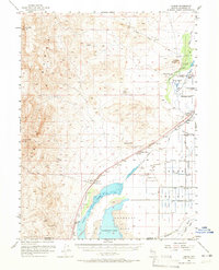
1956 Map of Toulon
USGS Topo · Published 1965About this map
The Humboldt Lake basin and the Toulon Lake bed define the hydrology of this arid corridor, where the Southern Pacific railroad follows the edge of the Trinity Mountains. Industrial activity is concentrated around the settlement of Toulon, which features several millponds and tailings piles, signaling the processing of ore from regional operations like the Coon Can Mines to the southwest. The presence of Derby Field and an Airway Beacon near the Humboldt River marks the importance of this valley for mid-century transportation and aviation navigation.
Find a feature on this map
52 named features on this map. Tap any name to fly to it.
Don’t see what you’re looking for? This feature index may not catch every label — zoom into the map to look around manually.
Map Details
Editions of this 1956 Toulon Map
4 editions found
Other maps of this area

1908 · Carson Sink
USGS Topo · 1:250,000

1910 · Carson Sink
USGS Topo · 1:250,000

1931 · Lovelock
USGS Topo · 1:250,000

1935 · Lovelock
USGS Topo · 1:250,000

1951 · Carson Sink
USGS Topo · 1:62,500

1951 · Desert Peak
USGS Topo · 1:62,500

1955 · Lovelock
USGS Topo · 1:250,000

1956 · Oreana
USGS Topo · 1:62,500

1956 · Toulon
USGS Topo · 1:62,500

1956 · Lovelock
USGS Topo · 1:62,500