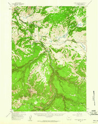
1959 Map of Tower Junction
USGS Topo · Published 1960About this map
Tower Junction serves as the focal point for this 1959 survey of the northern backcountry within Yellowstone National Park. The map documents a landscape where early park infrastructure meets dramatic geological transitions, notably where the Lamar River joins the Yellowstone River near Junction Butte. Human presence is marked by historic sites such as Yanceys, Pleasant Valley, and the established Roosevelt Lodge, alongside administrative outposts like the Hellroaring Ranger Sta and the Slough Creek Patrol Cabins.
Find a feature on this map
60 named features on this map. Tap any name to fly to it.
Don’t see what you’re looking for? This feature index may not catch every label — zoom into the map to look around manually.
Map Details
Editions of this 1959 Tower Junction Map
3 editions found
Other maps of this area

1885 · Gallatin
USGS Topo · 1:125,000

1885 · Gallatin
USGS Topo · 1:125,000

1886 · Canyon
USGS Topo · 1:125,000

1891 · Livingston
USGS Topo · 1:250,000

1893 · Livingston
USGS Topo · 1:250,000

1895 · Canyon
USGS Topo · 1:125,000

1896 · Canyon
USGS Topo · 1:125,000

1901 · Canyon
USGS Topo · 1:125,000

1901 · Gallatin
USGS Topo · 1:125,000

1907 · Canyon
USGS Topo · 1:125,000