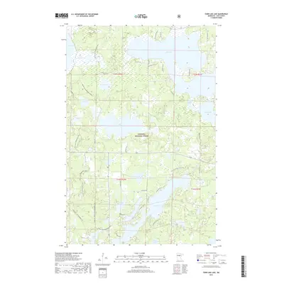
2019 Map of Town Line Lake
USGS Topo · Published 2019About this map
Chippewa National Forest defines the character of this northern landscape, which is dominated by a dense network of glacial lakes and recreational pathways. The central hub of water bodies includes Town Line Lake, Kego Lake, and Long Lake, while the vast Leech Lake and Boy Lake anchor the northern reaches. This 2019 survey documents a region deeply tied to seasonal recreation and conservation, showing the winding routes of the N Country National Scenic Trail and the Triville Gia Snowmobile Trail. For local historians and genealogists, the presence of Saint Edwards Cem near Maple Lake provides a specific point of interest in an area otherwise characterized by its wetlands and forest management tracks. The map illustrates how local access roads like Haskell Rd NE and Tobique Rd NE navigate the complex topography between Lundeen Lake and Crown Lake.
Find a feature on this map
43 named features on this map. Tap any name to fly to it.
Don’t see what you’re looking for? This feature index may not catch every label — zoom into the map to look around manually.
Map Details
Editions of this 2019 Town Line Lake Map
This is the sole edition of this map. No revisions or reprints were ever made.
Other maps of this area

1953 · Brainerd
USGS Topo · 1:250,000

1954 · Bemidji
USGS Topo · 1:250,000

1957 · Brainerd
USGS Topo · 1:250,000

1957 · Bemidji
USGS Topo · 1:250,000

1958 · Bemidji
USGS Topo · 1:250,000

1958 · Brainerd
USGS Topo · 1:250,000

1965 · Brainerd
USGS Topo · 1:250,000

1970 · Laura Lake
USGS Topo · 1:24,000

1970 · Woman Lake
USGS Topo · 1:24,000
1971 · Longville
USGS Topo · 1:24,000