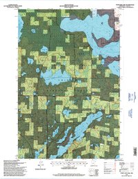
1996 Map of Town Line Lake
USGS Topo · Published 1998About this map
Chippewa National Forest and the Leech Lake Indian Reservation intersect in this watery landscape of North Central Minnesota, documented through aerial imagery and field checks in the late 1990s. The geography is dominated by complex lake systems, notably the sprawling Boy Lake with its eastern Rogers Bay and the elongated Long Lake to the south. Small family or community landmarks appear near these shorelines, including St Edwards Cemetery and a Church Camp situated near Rabbit Lake.
Find a feature on this map
28 named features on this map. Tap any name to fly to it.
Don’t see what you’re looking for? This feature index may not catch every label — zoom into the map to look around manually.
Map Details
Editions of this 1996 Town Line Lake Map
This is the sole edition of this map. No revisions or reprints were ever made.
Other maps of this area

1953 · Brainerd
USGS Topo · 1:250,000

1954 · Bemidji
USGS Topo · 1:250,000

1957 · Brainerd
USGS Topo · 1:250,000

1957 · Bemidji
USGS Topo · 1:250,000

1958 · Bemidji
USGS Topo · 1:250,000

1958 · Brainerd
USGS Topo · 1:250,000

1965 · Brainerd
USGS Topo · 1:250,000

1970 · Laura Lake
USGS Topo · 1:24,000

1970 · Woman Lake
USGS Topo · 1:24,000
1971 · Longville
USGS Topo · 1:24,000