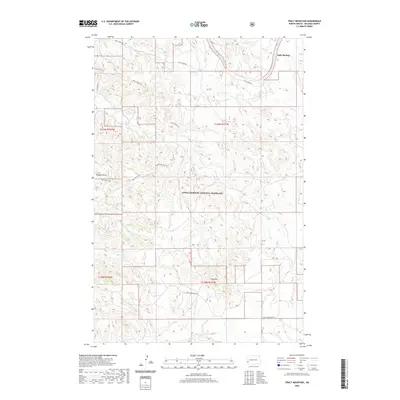
2020 Map of Tracy Mountain
USGS Topo · Published 2020About this map
Sully Springs occupies the northeast corner of this map, situated within the expansive Little Missouri National Grassland. The landscape is defined by the high point of Tracy Mtn and a complex drainage system including Sully Cr, Davis Cr, and Merrifield Cr. This 2020 survey illustrates the remote character of Billings County, where historical transit routes like the Maah Daah Hey trail navigate the broken terrain of Plumley Draw. Local access is provided by unpaved thoroughfares such as Sully Creek Rd and Tracy Mountain Rd. The map detail captures the unique topography of the North Dakota badlands, showing how modern land management and recreation intersect with established natural landmarks and small drainage basins like Little Cr and Dantz Cr.
Find a feature on this map
16 named features on this map. Tap any name to fly to it.
Don’t see what you’re looking for? This feature index may not catch every label — zoom into the map to look around manually.
Map Details
Editions of this 2020 Tracy Mountain Map
This is the sole edition of this map. No revisions or reprints were ever made.
Other maps of this area

1953 · Dickinson
USGS Topo · 1:250,000

1957 · Dickinson
USGS Topo · 1:250,000

1961 · Rocky Ridge
USGS Topo · 1:62,500

1962 · Tracy Mountain
USGS Topo · 1:24,000

1962 · Fryburg NE
USGS Topo · 1:24,000

1962 · Fryburg
USGS Topo · 1:24,000

1962 · Fryburg NW
USGS Topo · 1:24,000

1970 · Medora
USGS Topo · 1:24,000
1979 · Chimney Butte
USGS Topo · 1:24,000

1979 · Bullion Butte
USGS Topo · 1:24,000