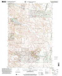
1997 Map of Tracy Mountain
USGS Topo · Published 2001About this map
The Little Missouri National Grassland dominates this North Dakota landscape, where the interplay of public land management and energy extraction is clearly visible. The rugged terrain is punctuated by the Fryburg Oil Field, with numerous wells, a Tank Battery, and a Compressor Station connected by the Fryburg Oil Field Road. This industrial layer exists alongside traditional western land uses, as evidenced by several named homesteads including Richards Ranch, Shade Ranch, and Porter Ranch.
Find a feature on this map
18 named features on this map. Tap any name to fly to it.
Don’t see what you’re looking for? This feature index may not catch every label — zoom into the map to look around manually.
Map Details
Editions of this 1997 Tracy Mountain Map
This is the sole edition of this map. No revisions or reprints were ever made.
Other maps of this area

1953 · Dickinson
USGS Topo · 1:250,000

1957 · Dickinson
USGS Topo · 1:250,000

1961 · Rocky Ridge
USGS Topo · 1:62,500

1962 · Tracy Mountain
USGS Topo · 1:24,000

1962 · Fryburg NE
USGS Topo · 1:24,000

1962 · Fryburg
USGS Topo · 1:24,000

1962 · Fryburg NW
USGS Topo · 1:24,000

1970 · Medora
USGS Topo · 1:24,000
1979 · Chimney Butte
USGS Topo · 1:24,000

1979 · Bullion Butte
USGS Topo · 1:24,000