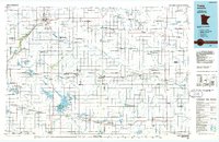
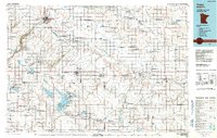
1986 Map of Tracy
USGS Topo · Published 1986About this map
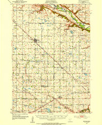
The Chicago and North Western railroad corridor dictates the settlement pattern across this southwestern Minnesota landscape, connecting prairie towns like Tracy, Walnut Grove, and Lamberton. To the north, Marshall serves as a significant regional hub, flanked by Lake Marshall and Three Mile Creek. The map reveals a land heavily managed for conservation and drainage, evidenced by dozens of wildlife areas such as the Great Oasis State Wildlife Management Area and the Prairie Marshes State Wildlife Management Area.
Find a feature on this map
191 named features on this map. Tap any name to fly to it.
Don’t see what you’re looking for? This feature index may not catch every label — zoom into the map to look around manually.
Map Details
Editions of this 1986 Tracy Map
2 editions found
Other maps of this area
1952 · Morton
USGS Topo · 1:62,500
1952 · Redwood Falls
USGS Topo · 1:62,500
1953 · Morgan
USGS Topo · 1:62,500

1953 · Watertown
USGS Topo · 1:250,000

1953 · New Ulm
USGS Topo · 1:250,000

1954 · Fairmont
USGS Topo · 1:250,000

1955 · Sioux Falls
USGS Topo · 1:250,000

1957 · New Ulm
USGS Topo · 1:250,000

1958 · New Ulm
USGS Topo · 1:250,000

1958 · Sioux Falls
USGS Topo · 1:250,000