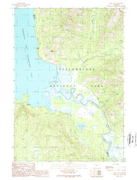
1989 Map of Trail Lake
USGS Topo · Published 1989About this map
Yellowstone Lake dominates the western edge of this landscape, its Southeast Arm reaching into a wilderness defined by high plateaus and remote patrol outposts. In the late 1980s, this backcountry region shows a network of historical transit routes, most notably the Thorofare Trail which skirts the shoreline near Terrace Point. Evidence of early exploration and park management is preserved through landmarks like Langford Cairn and the remote Trail Creek Patrol Cabin.
Find a feature on this map
19 named features on this map. Tap any name to fly to it.
Don’t see what you’re looking for? This feature index may not catch every label — zoom into the map to look around manually.
Map Details
Editions of this 1989 Trail Lake Map
This is the sole edition of this map. No revisions or reprints were ever made.
Other maps of this area

1885 · Lake
USGS Topo · 1:125,000

1895 · Lake
USGS Topo · 1:125,000

1896 · Lake
USGS Topo · 1:125,000

1901 · Lake
USGS Topo · 1:125,000

1906 · Lake
USGS Topo · 1:125,000

1911 · Lake
USGS Topo · 1:125,000

1955 · Ashton
USGS Topo · 1:250,000

1958 · Ashton
USGS Topo · 1:250,000
1959 · Mount Hancock
USGS Topo · 1:62,500
1959 · Two Ocean Pass
USGS Topo · 1:62,500