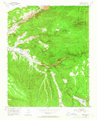
1953 Map of Trampas
USGS Topo · Published 1965About this map
Las Trampas Grant and the Sebastian Martin Grant intersect in this mountainous landscape of northern New Mexico, where deep canyons and high mesas define the local geography. In the early 1950s, small settlements like Trampas and Escuela de Abajo clustered along the watercourses, anchored by community landmarks such as the Iglesia de Santo Tomas. The terrain is characterized by a series of prominent peaks, including Cerro de las Marquenas and Cerro Puntiagudo, while the Rio Grande flows through the Grande Canyon in the northwestern corner.
Find a feature on this map
57 named features on this map. Tap any name to fly to it.
Don’t see what you’re looking for? This feature index may not catch every label — zoom into the map to look around manually.
Map Details
Editions of this 1953 Trampas Map
3 editions found
Other maps of this area

1953 · Truchas
USGS Topo · 1:24,000

1953 · Velarde
USGS Topo · 1:24,000

1953 · Trampas
USGS Topo · 1:24,000

1953 · Chimayo
USGS Topo · 1:24,000

1954 · Raton
USGS Topo · 1:250,000

1958 · Raton
USGS Topo · 1:250,000

1960 · Taos Junction
USGS Topo · 1:24,000

1961 · Carson
USGS Topo · 1:24,000

1964 · Penasco
USGS Topo · 1:24,000

1964 · Taos SW
USGS Topo · 1:24,000