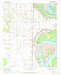
1970 Map of Transylvania
USGS Topo · Published 1972About this map
Indian Mounds and the remains of ancient settlements line the western edge of the Mississippi floodplain in this 1970 snapshot of East Carroll Parish. The Missouri Pacific railroad forms the spine of the local economy, connecting rural communities like Hollybrook, Atherton, and Transylvania. The landscape is a complex web of drainage engineering and alluvial history, defined by a network of numbered ditches and natural waterways such as Sandy Bayou and Otter Bayou. Along the Mississippi River, the shifting banks are evidenced by the massive Cottonwood Bar and a prominent Levee system protecting the low-lying agricultural fields. Cultural landmarks are scattered throughout the quadrangle, including numerous rural houses of worship like Mound Chapel and Morning Star Ch, alongside family or community burial sites like Cold Tar Cem and Benjamin Cem.
Find a feature on this map
40 named features on this map. Tap any name to fly to it.
Don’t see what you’re looking for? This feature index may not catch every label — zoom into the map to look around manually.
Map Details
Editions of this 1970 Transylvania Map
2 editions found
Other maps of this area

1909 · Baxter Bayou
USGS Topo · 1:24,000

1909 · Lake Providence
USGS Topo · 1:24,000

1911 · Lake Providence
USGS Topo · 1:31,680

1911 · Baxter Bayou
USGS Topo · 1:24,000

1914 · Baxter Bayou
USGS Topo · 1:31,680

1935 · Oak Grove
USGS Topo · 1:62,500

1939 · Alsatia
USGS Topo · 1:62,500

1939 · Mayersville
USGS Topo · 1:62,500

1955 · Jackson
USGS Topo · 1:250,000

1958 · Oak Grove
USGS Topo · 1:62,500