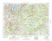
1954 Map of Traverse City
USGS Topo · Published 1984About this map
Traverse City and the northern lower peninsula of Michigan are mapped here during a period of mid-century growth and conservation. The landscape is defined by its massive state and national forests, including the Huron National Forest and Manistee National Forest, which dominate the central and eastern portions of the quadrangle. This 1950s data reveals a robust transportation network before the expansion of the modern interstate system, showing the prominent role of the Pennsylvania RR and Ann Arbor RR in connecting lakeside communities like Beulah and Frankfort. The map captures the significant presence of the Camp Grayling Military Reservation and the burgeoning recreation areas around Houghton Lake and Higgins Lake. Coastal details such as Sleeping Bear Plateau and Grand Traverse Bay underscore the region's reliance on its maritime geography and growing post-war tourism industry.
Find a feature on this map
244 named features on this map. Tap any name to fly to it.
Don’t see what you’re looking for? This feature index may not catch every label — zoom into the map to look around manually.
Map Details
Editions of this 1954 Traverse City Map
4 editions found

Other maps of this area

1931 · Baldwin NW
USGS Topo · 1:31,680

1931 · Custer NE
USGS Topo · 1:31,680

1931 · Chase NE
USGS Topo · 1:31,680

1931 · Baldwin NE
USGS Topo · 1:31,680

1932 · Freesoil SE
USGS Topo · 1:31,680

1932 · Chase NW
USGS Topo · 1:31,680

1933 · Peacock SE
USGS Topo · 1:31,680

1933 · Peacock SW
USGS Topo · 1:31,680

1933 · Luther SE
USGS Topo · 1:31,680

1933 · Peacock NE
USGS Topo · 1:31,680
Featured Places
- Garfield Township, MI
- Garfield Charter Township, Garfield Township
- Traverse City, MI
- East Bay Township, MI
- East Bay Charter Township, East Bay Township