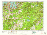
1958 Map of Traverse City
USGS Topo · Published 1958About this map
Traverse City anchors this 1950s survey of Northern Michigan, where the rugged coastline of Lake Michigan meets the expansive timberlands of the Huron National Forest and Au Sable State Forest. The map details the intricate geography of the Grand Traverse region, from the narrow finger of Old Mission Point dividing the bay to the shorelines of Glen Lake and Torch Lake. Inland, the landscape is defined by massive water bodies like Higgins Lake and Houghton Lake, and the winding course of the Au Sable River.
Find a feature on this map
211 named features on this map. Tap any name to fly to it.
Don’t see what you’re looking for? This feature index may not catch every label — zoom into the map to look around manually.
Map Details
Editions of this 1958 Traverse City Map
2 editions found

Other maps of this area

1931 · Baldwin NW
USGS Topo · 1:31,680

1931 · Custer NE
USGS Topo · 1:31,680

1931 · Chase NE
USGS Topo · 1:31,680

1931 · Baldwin NE
USGS Topo · 1:31,680

1932 · Freesoil SE
USGS Topo · 1:31,680

1932 · Chase NW
USGS Topo · 1:31,680

1933 · Peacock SE
USGS Topo · 1:31,680

1933 · Peacock SW
USGS Topo · 1:31,680

1933 · Luther SE
USGS Topo · 1:31,680

1933 · Peacock NE
USGS Topo · 1:31,680
Featured Places
- Garfield Township, MI
- Garfield Charter Township, Garfield Township
- Traverse City, MI
- East Bay Township, MI
- East Bay Charter Township, East Bay Township