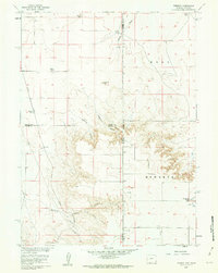
1960 Map of Tremain
USGS Topo · Published 1962About this map
High plains ranching and the sharp relief of the Wyoming-Nebraska borderland define this 1960 landscape. Named ranching homesteads like Tremain Ranch, Johnson Ranch, and McClure Ranch are scattered across the terrain, illustrating the sparse but established settlement patterns of the era. The Union Pacific line cuts through the western portion of the sheet, providing a vital transportation artery for the region's agricultural economy.
Find a feature on this map
21 named features on this map. Tap any name to fly to it.
Don’t see what you’re looking for? This feature index may not catch every label — zoom into the map to look around manually.
Map Details
Editions of this 1960 Tremain Map
3 editions found
Other maps of this area

1898 · Scotts Bluff
USGS Topo · 1:125,000

1899 · Goshen Hole
USGS Topo · 1:125,000

1954 · Scottsbluff
USGS Topo · 1:250,000

1954 · Cheyenne
USGS Topo · 1:250,000

1958 · Cheyenne
USGS Topo · 1:250,000

1958 · Scottsbluff
USGS Topo · 1:250,000

1960 · Tremain
USGS Topo · 1:24,000

1960 · Mc Compsey Pass
USGS Topo · 1:24,000

1960 · Petsch Reservoir
USGS Topo · 1:24,000

1960 · La Grange
USGS Topo · 1:24,000