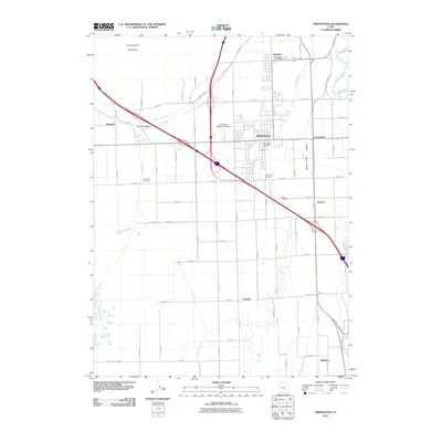
2011 Map of Tremonton
USGS Topo · Published 2011About this map
Tremonton serves as the central hub of this agricultural and transit corridor within the Bear River Valley. The landscape is defined by an extensive network of irrigation and water management features, including the Highline Canal, West Canal, and the Mill Ditch, which support the surrounding farmland. To the northwest, the Point Lookout Mountains rise above the valley floor, providing a sharp contrast to the level fields below. This 2011 survey documents the intersection of modern interstate travel with established local landmarks like the Riverview Cemetery and the Tremonton Municipal Airport. The map also captures smaller communities and historical points of interest such as Bothwell, Elwood, and Garland, where the Garland Post Office remains a focal point for the rural population.
Find a feature on this map
41 named features on this map. Tap any name to fly to it.
Don’t see what you’re looking for? This feature index may not catch every label — zoom into the map to look around manually.
Map Details
Editions of this 2011 Tremonton Map
This is the sole edition of this map. No revisions or reprints were ever made.
Other maps of this area

1954 · Public Shooting Grounds
USGS Topo · 1:24,000

1954 · Brigham City
USGS Topo · 1:250,000

1955 · Bear River City
USGS Topo · 1:24,000

1955 · Brigham City
USGS Topo · 1:24,000

1958 · Brigham City
USGS Topo · 1:250,000

1961 · Thatcher Mountain
USGS Topo · 1:62,500

1961 · Honeyville
USGS Topo · 1:24,000

1961 · Tremonton
USGS Topo · 1:24,000

1962 · Brigham City
USGS Topo · 1:250,000
1964 · Riverside
USGS Topo · 1:24,000