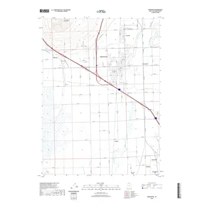
2020 Map of Tremonton
USGS Topo · Published 2020About this map
The Malad River and Bear River converge within the wide agricultural basin of the Bear River Valley in this detailed 2020 survey. The landscape is defined by a dense grid of irrigation infrastructure, including the Highline Canal, Mill Ditch, and Sulphur Cr, which support the high-density farming operations surrounding the central hubs of Tremonton and Garland. The Point Lookout Mountains rise sharply in the northwest, anchored by the prominent Point Lookout peak, providing a natural barrier to the valley's expanse.
Find a feature on this map
60 named features on this map. Tap any name to fly to it.
Don’t see what you’re looking for? This feature index may not catch every label — zoom into the map to look around manually.
Map Details
Editions of this 2020 Tremonton Map
This is the sole edition of this map. No revisions or reprints were ever made.
Other maps of this area

1954 · Public Shooting Grounds
USGS Topo · 1:24,000

1954 · Brigham City
USGS Topo · 1:250,000

1955 · Bear River City
USGS Topo · 1:24,000

1955 · Brigham City
USGS Topo · 1:24,000

1958 · Brigham City
USGS Topo · 1:250,000

1961 · Thatcher Mountain
USGS Topo · 1:62,500

1961 · Honeyville
USGS Topo · 1:24,000

1961 · Tremonton
USGS Topo · 1:24,000

1962 · Brigham City
USGS Topo · 1:250,000
1964 · Riverside
USGS Topo · 1:24,000