1989 Map of Tremonton
USGS Topo · Published 1989About this map
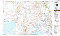
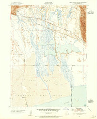
The Golden Spike National Historic Site stands as a focal point of this Northern Utah landscape, marking the monumental meeting of the rails where Lampo Junction and the Union Pacific Railroad traverse the desert terrain. To the east, the agricultural corridor of the Bear River valley is densely settled with communities like Tremonton, Garland, and Brigham City. The map captures the complex irrigation and water management systems essential to this region, featuring the Hammond Canal and West Side Canal alongside the massive Cutler Reservoir. In the south, the transition from the Wellsville Mountains to the expansive wetlands of the Bear River National Migratory Bird Refuge and Spring Bay on the Great Salt Lake illustrates the diverse ecology of the Basin and Range province. Settlements such as Washakie and Honeyville offer valuable data points for those researching local history and family lineages.
Find a feature on this map
67 named features on this map. Tap any name to fly to it.
Don’t see what you’re looking for? This feature index may not catch every label — zoom into the map to look around manually.
Map Details
Editions of this 1989 Tremonton Map
2 editions found

Other maps of this area

1914 · Logan
USGS Topo · 1:125,000

1915 · Preston
USGS Topo · 1:96,000

1916 · Logan
USGS Topo · 1:125,000

1918 · Preston
USGS Topo · 1:125,000

1954 · Whistler Canal
USGS Topo · 1:24,000
1954 · Public Shooting Grounds
USGS Topo · 1:24,000

1954 · Pocatello
USGS Topo · 1:250,000

1954 · Ogden
USGS Topo · 1:250,000

1954 · Brigham City
USGS Topo · 1:250,000
1955 · Mantua
USGS Topo · 1:24,000