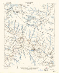
1904 Map of Trent River
USGS Topo · Published 1946About this map
Trenton serves as a central hub along the winding Trent River in this survey of Jones and Craven Counties, conducted just after the turn of the century. The landscape is defined by its extensive wetlands and water-dependent commerce, characterized by the Great Dover Swamp and the Whiteoak Pocoson. A dense network of landings along the river, such as Wooten Landing, Mallard Cove Landing, and Murrill Landing, indicates a vibrant period of riverine transport and trade before the dominance of modern highways.
Find a feature on this map
72 named features on this map. Tap any name to fly to it.
Don’t see what you’re looking for? This feature index may not catch every label — zoom into the map to look around manually.
Map Details
Editions of this 1904 Trent River Map
3 editions found
Other maps of this area

1901 · New Bern
USGS Topo · 1:62,500

1902 · Ayden
USGS Topo · 1:62,500

1902 · Vanceboro
USGS Topo · 1:62,500

1903 · New Bern
USGS Topo · 1:62,500

1903 · Trent River
USGS Topo · 1:62,500

1904 · Ayden
USGS Topo · 1:62,500

1904 · Trent River
USGS Topo · 1:62,500

1904 · Vanceboro
USGS Topo · 1:62,500

1905 · Vanceboro
USGS Topo · 1:62,500

1914 · Kinston
USGS Topo · 1:48,000