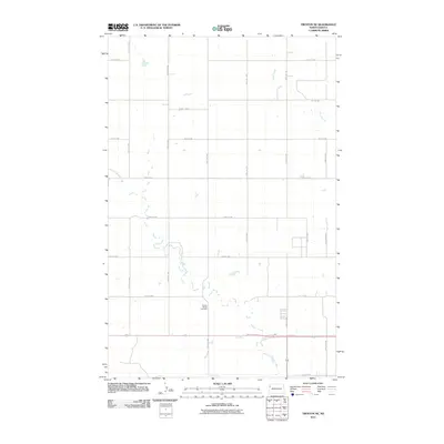
2011 Map of Trenton NE
USGS Topo · Published 2011About this map
Painted Woods Creek and Sand Creek define the drainage patterns across this section of Williams County, where the landscape is organized by a strict geometric grid of section lines and gravel roads. This 2011 survey reveals the sparsely populated rural character of the region north of the Missouri River valley. The most significant historical marker on the map is the Painted Woods Cemetery, located in the southern portion of the quadrangle near the intersection of 145th Ave NW and 51st St NW. The network of secondary routes like County Hwy-6 and County Hwy-4 provides access to scattered farmsteads and agricultural plots that dominate the terrain, illustrating the enduring homesteading patterns that shaped the North Dakota plains.
Find a feature on this map
19 named features on this map. Tap any name to fly to it.
Don’t see what you’re looking for? This feature index may not catch every label — zoom into the map to look around manually.
Map Details
Editions of this 2011 Trenton NE Map
This is the sole edition of this map. No revisions or reprints were ever made.
Other maps of this area

1953 · Williston
USGS Topo · 1:250,000

1957 · Williston
USGS Topo · 1:250,000

1959 · Williston West
USGS Topo · 1:24,000

1968 · Trenton SW
USGS Topo · 1:24,000

1969 · Trenton
USGS Topo · 1:24,000

1974 · Otter Tail Creek
USGS Topo · 1:24,000

1974 · Bonetraill SW
USGS Topo · 1:24,000

1974 · Trenton NE
USGS Topo · 1:24,000
1974 · Trenton NW
USGS Topo · 1:24,000
1974 · Bonetraill SE
USGS Topo · 1:24,000