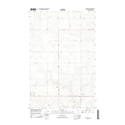
2014 Map of Trenton NE
USGS Topo · Published 2014About this map
Bobs Coulee and the meandering path of Sand Cr define the undulating geography of this Williams County landscape in the early 21st century. The map reveals a strictly organized grid of rural section lines, with roads like 50th St NW and 145th Ave NW providing the primary framework for movement through the high prairie. A notable site of local history and genealogy is the Painted Woods Cem, situated near the center of the survey. The naming of Painted Woods Dr further emphasizes the enduring legacy of this specific locality. The transition from the established Round Prairie Ave to the newer stretches of E Round Prairie Ave suggests a landscape shaped by long-standing agricultural boundaries and modern infrastructure planning.
Find a feature on this map
22 named features on this map. Tap any name to fly to it.
Don’t see what you’re looking for? This feature index may not catch every label — zoom into the map to look around manually.
Map Details
Editions of this 2014 Trenton NE Map
This is the sole edition of this map. No revisions or reprints were ever made.
Other maps of this area

1953 · Williston
USGS Topo · 1:250,000

1957 · Williston
USGS Topo · 1:250,000

1959 · Williston West
USGS Topo · 1:24,000

1968 · Trenton SW
USGS Topo · 1:24,000

1969 · Trenton
USGS Topo · 1:24,000

1974 · Otter Tail Creek
USGS Topo · 1:24,000

1974 · Bonetraill SW
USGS Topo · 1:24,000

1974 · Trenton NE
USGS Topo · 1:24,000
1974 · Trenton NW
USGS Topo · 1:24,000
1974 · Bonetraill SE
USGS Topo · 1:24,000