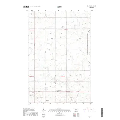
2020 Map of Trenton NE
USGS Topo · Published 2020About this map
Painted Woods Cr and Sand Cr wind through the section lines of Williams County, defining a landscape marked by both traditional rural markers and recent residential development. The presence of the Saint Paul Lutheran Cem in the north and the Painted Woods Cem near the center provides significant genealogical touchstones for families settled in this part of North Dakota. In the southern portion of the quadrangle, a more structured street grid emerges with names like Mortenson St NW, Brigham Dr, and Commerce Park Blvd, illustrating the expansion of settlements near the Missouri River valley. The terrain is characterized by draws and breaks such as Bobs Coulee, which disrupt the otherwise orderly township and range system of T154N and T155N.
Find a feature on this map
38 named features on this map. Tap any name to fly to it.
Don’t see what you’re looking for? This feature index may not catch every label — zoom into the map to look around manually.
Map Details
Editions of this 2020 Trenton NE Map
This is the sole edition of this map. No revisions or reprints were ever made.
Other maps of this area

1953 · Williston
USGS Topo · 1:250,000

1957 · Williston
USGS Topo · 1:250,000

1959 · Williston West
USGS Topo · 1:24,000

1968 · Trenton SW
USGS Topo · 1:24,000

1969 · Trenton
USGS Topo · 1:24,000

1974 · Otter Tail Creek
USGS Topo · 1:24,000

1974 · Bonetraill SW
USGS Topo · 1:24,000

1974 · Trenton NE
USGS Topo · 1:24,000
1974 · Trenton NW
USGS Topo · 1:24,000
1974 · Bonetraill SE
USGS Topo · 1:24,000