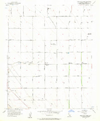
1956 Map of Tres Picos Farms
USGS Topo · Published 1963About this map
Agricultural development and irrigation infrastructure define the landscape of Fresno County during the mid-1950s, as shown on this survey. The terrain transitions from the Big Blue Hills in the southwest toward a grid of industrialized farmland in the valley. Vital water management features like the Canal, a large Reservoir, and a protective Levee support the region's productivity. The map documents the localized centers of this economy, including Tres Picos Farms and the Cotton Gin near Cantua Creek. Scattered Labor Camp sites, a dedicated Landing Strip, and private holdings like Terry Ranch and Farrell Ranch illustrate the organized, large-scale nature of Central Valley ranching and farming operations during this era. Industrial infrastructure is further evidenced by clusters of Oil Tanks and Gas Tanks throughout the territory.
Find a feature on this map
26 named features on this map. Tap any name to fly to it.
Don’t see what you’re looking for? This feature index may not catch every label — zoom into the map to look around manually.
Map Details
Editions of this 1956 Tres Picos Farms Map
4 editions found
Other maps of this area

1912 · Coalinga
USGS Topo · 1:125,000

1923 · Levis
USGS Topo · 1:31,680

1923 · Englebrecht Ranch
USGS Topo · 1:31,680

1925 · San Joaquin
USGS Topo · 1:31,680

1928 · Delta Farms No 3
USGS Topo · 1:31,680

1931 · Towne Oil Station
USGS Topo · 1:31,680

1931 · Mouth of Cantua Creek
USGS Topo · 1:31,680

1932 · Delta Farms
USGS Topo · 1:31,680

1943 · Joaquin Rocks
USGS Topo · 1:62,500

1946 · Tranquillity
USGS Topo · 1:62,500