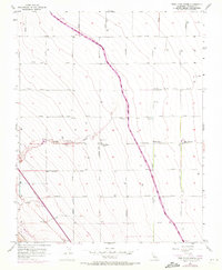
1956 Map of Tres Picos Farms
USGS Topo · Published 1972About this map
California Aqueduct defines the industrial and agricultural rhythm of this Central Valley landscape, slicing diagonally across the terrain as it carries water southward. In this mid-century environment, the grid-based road system includes named thoroughfares such as Mt Whitney Avenue and Elkhorn Avenue, which intersect near local operations like Tres Picos Farms and the Cantua Substation. The presence of several wells, a Gas Well, and Grain Tanks indicates a dual reliance on large-scale ranching and mineral extraction.
Find a feature on this map
29 named features on this map. Tap any name to fly to it.
Don’t see what you’re looking for? This feature index may not catch every label — zoom into the map to look around manually.
Map Details
Editions of this 1956 Tres Picos Farms Map
4 editions found
Other maps of this area

1912 · Coalinga
USGS Topo · 1:125,000

1923 · Levis
USGS Topo · 1:31,680

1923 · Englebrecht Ranch
USGS Topo · 1:31,680

1925 · San Joaquin
USGS Topo · 1:31,680

1928 · Delta Farms No 3
USGS Topo · 1:31,680

1931 · Towne Oil Station
USGS Topo · 1:31,680

1931 · Mouth of Cantua Creek
USGS Topo · 1:31,680

1932 · Delta Farms
USGS Topo · 1:31,680

1943 · Joaquin Rocks
USGS Topo · 1:62,500

1946 · Tranquillity
USGS Topo · 1:62,500