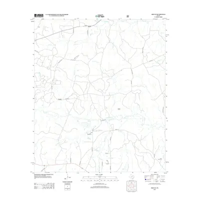
2013 Map of Trevat
USGS Topo · Published 2013About this map
The small settlement of Trevat serves as the focal point for this rural landscape in eastern Texas, characterized by an intricate network of creeks and timbered drainages. Located along the path of several local thoroughfares like Carmona Rd and Hamilton Rd, the community sits near the northern boundary where Alabama Cr flows. To the south, the settlement of Sulphur is positioned near the banks of Sulphur Cr and Piney Cr. For researchers and genealogists, the presence of the Wagner Hill Cem and Abbott Springs Cem provides essential points of reference for local family histories. The terrain is marked by seasonal water features like Dry Lake and numerous branches including White Oak Cr and Brushy Cr, illustrating the hydrological patterns of the Trinity County region before modern development altered these traditional drainage basins.
Find a feature on this map
43 named features on this map. Tap any name to fly to it.
Don’t see what you’re looking for? This feature index may not catch every label — zoom into the map to look around manually.
Map Details
Editions of this 2013 Trevat Map
This is the sole edition of this map. No revisions or reprints were ever made.
Other maps of this area

1953 · Palestine
USGS Topo · 1:250,000

1954 · Beaumont
USGS Topo · 1:250,000

1955 · New Willard
USGS Topo · 1:62,500

1957 · Beaumont
USGS Topo · 1:250,000

1957 · Palestine
USGS Topo · 1:250,000

1960 · Colita
USGS Topo · 1:24,000

1963 · Crecy
USGS Topo · 1:24,000

1963 · Groveton East
USGS Topo · 1:24,000
1963 · Apple Springs
USGS Topo · 1:24,000
1963 · Diboll
USGS Topo · 1:24,000