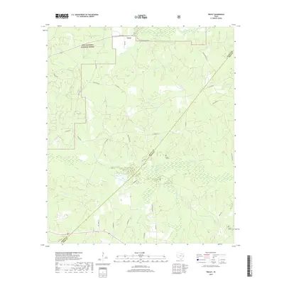
2019 Map of Trevat
USGS Topo · Published 2019About this map
Davy Crockett National Forest dominates the northwest corner of this Piney Woods landscape, where the northern border of Trinity County meets the headwaters of numerous creeks. The settlement of Trevat serves as a small anchor point along FM 2262, situated near the confluence of James Creek and Alabama Creek. The terrain is defined by its complex hydrography, with significant drainages like Piney Creek and White Oak Creek carving through the wooded lowlands.
Find a feature on this map
40 named features on this map. Tap any name to fly to it.
Don’t see what you’re looking for? This feature index may not catch every label — zoom into the map to look around manually.
Map Details
Editions of this 2019 Trevat Map
This is the sole edition of this map. No revisions or reprints were ever made.
Other maps of this area

1953 · Palestine
USGS Topo · 1:250,000

1954 · Beaumont
USGS Topo · 1:250,000

1955 · New Willard
USGS Topo · 1:62,500

1957 · Beaumont
USGS Topo · 1:250,000

1957 · Palestine
USGS Topo · 1:250,000

1960 · Colita
USGS Topo · 1:24,000

1963 · Crecy
USGS Topo · 1:24,000

1963 · Groveton East
USGS Topo · 1:24,000
1963 · Apple Springs
USGS Topo · 1:24,000
1963 · Diboll
USGS Topo · 1:24,000