
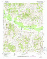
1966 Map of Trezevant West
USGS Topo · Published 1968About this map
The South Fork Obion River meanders through this West Tennessee landscape, marking the confluence of Carroll, Weakley, and Gibson Counties. Small agricultural hubs like Staffords Store, Holly Leaf, and the community of Christmasville define the rural character of the area in the mid-1960s. The settlement pattern is anchored by a network of country churches, including Republican Grove Ch, Pleasant Green Ch, and Pilgrims Ch, which served as the social heart of these farming communities.
Find a feature on this map
29 named features on this map. Tap any name to fly to it.
Don’t see what you’re looking for? This feature index may not catch every label — zoom into the map to look around manually.
Map Details
Editions of this 1966 Trezevant West Map
2 editions found
Other maps of this area

1952 · Milan
USGS Topo · 1:24,000

1954 · Greenfield
USGS Topo · 1:24,000

1954 · Bradford
USGS Topo · 1:24,000

1956 · Dyersburg
USGS Topo · 1:250,000

1956 · Blytheville
USGS Topo · 1:250,000

1959 · Blytheville
USGS Topo · 1:250,000

1966 · Mc Lemoresville
USGS Topo · 1:24,000

1966 · Atwood
USGS Topo · 1:24,000

1967 · Pillowville
USGS Topo · 1:24,000
1967 · Trezevant East
USGS Topo · 1:24,000