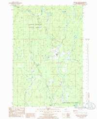
1985 Map of Triangle Ranch
USGS Topo · Published 1986About this map
The Copper Country State Forest dominates this section of Iron County, Michigan, characterized by its complex network of waterways and the historic Hematite township line. The landscape is defined by the convergence of the West Branch Hemlock River and East Branch Hemlock River, which flow alongside a north-south Railroad corridor. These water systems, including the Nelson River and East Branch Net River, likely dictated the early transport and resource extraction patterns of the Upper Peninsula.
Find a feature on this map
19 named features on this map. Tap any name to fly to it.
Don’t see what you’re looking for? This feature index may not catch every label — zoom into the map to look around manually.
Map Details
Editions of this 1985 Triangle Ranch Map
This is the sole edition of this map. No revisions or reprints were ever made.
Other maps of this area

1895 · Ned Lake
USGS Topo · 1:62,500

1895 · Perch Lake
USGS Topo · 1:62,500

1898 · Iron River
USGS Topo · 1:62,500

1899 · Crystal Falls
USGS Topo · 1:62,500

1945 · Sunset Lake
USGS Topo · 1:24,000

1945 · Kelso Junction
USGS Topo · 1:24,000

1945 · Amasa
USGS Topo · 1:24,000

1946 · Sunset Lake
USGS Topo · 1:31,680
1947 · Amasa
USGS Topo · 1:24,000

1947 · Kelso Junction
USGS Topo · 1:24,000