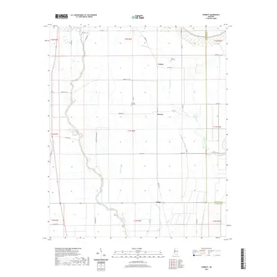
2020 Map of Tribbett
USGS Topo · Published 2020About this map
Bogue Phalia and its winding tributaries dominate this Mississippi Delta landscape, defining a region characterized by expansive agricultural tracts and quiet rural settlements. Located in Washington and Sunflower Counties, the area centers on Bourbon and Tribbett, where the straight-line geometry of plantation roads like Marta Plantation Rd and Kennedy Flat Rd contrasts with the organic curves of the bayous. Small communities such as Tralake sit at the intersection of local routes, while several local cemeteries, including Bethlehem Cem, Mount Zion Cem, and Kindling Altar Cem, provide critical points of reference for genealogists. The intricate drainage network of Sixmile Bayou, Jones Bayou, and Deep Slough illustrates the complex hydrology required to manage the fertile delta lands, which remain largely devoted to large-scale farming operations.
Find a feature on this map
46 named features on this map. Tap any name to fly to it.
Don’t see what you’re looking for? This feature index may not catch every label — zoom into the map to look around manually.
Map Details
Editions of this 2020 Tribbett Map
This is the sole edition of this map. No revisions or reprints were ever made.
Other maps of this area

1939 · Tralake
USGS Topo · 1:62,500

1939 · Swan Lake
USGS Topo · 1:62,500

1940 · Auter
USGS Topo · 1:62,500

1940 · Baird
USGS Topo · 1:62,500

1953 · Greenwood
USGS Topo · 1:250,000

1956 · Greenwood
USGS Topo · 1:250,000

1965 · Indianola
USGS Topo · 1:24,000

1965 · Kinlock
USGS Topo · 1:24,000
1965 · Midnight NW
USGS Topo · 1:24,000

1967 · Baird
USGS Topo · 1:62,500