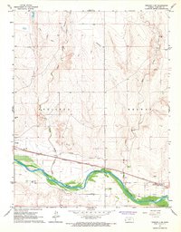
1966 Map of Tribune 3 SW
USGS Topo · Published 1967About this map
The Arkansas River winds through this western Kansas landscape, anchoring a complex network of water management features essential to the region's agricultural history. The transition from earlier irrigation efforts to mid-century infrastructure is visible in the presence of the Amity Canal (Abandoned), which contrasts with active water routes like the Frontier Ditch and Alamo Ditch. Along the northern bank, the Atchison Topeka and Santa Fe railroad serves as the primary transportation artery, passing through the small community of Coolidge.
Find a feature on this map
23 named features on this map. Tap any name to fly to it.
Don’t see what you’re looking for? This feature index may not catch every label — zoom into the map to look around manually.
Map Details
Editions of this 1966 Tribune 3 SW Map
2 editions found
Other maps of this area

1890 · Granada
USGS Topo · 1:125,000

1891 · Albany
USGS Topo · 1:125,000

1892 · Granada
USGS Topo · 1:125,000

1893 · Albany
USGS Topo · 1:125,000

1894 · Granada
USGS Topo · 1:125,000

1900 · Syracuse
USGS Topo · 1:125,000

1920 · Syracuse
USGS Topo · 1:125,000

1953 · Holly East
USGS Topo · 1:24,000

1954 · Lamar
USGS Topo · 1:250,000

1955 · Holly NE
USGS Topo · 1:24,000