
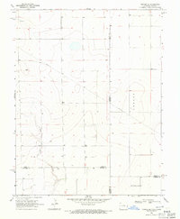
2010 Map of Tribune NW
USGS Topo · Published 2010About this map
Rogers Cemetery and Mathews Cemetery stand as quiet landmarks within this rural expanse of Greeley County. The terrain is defined by a strict orthogonal grid of local routes such as Co RD O and Co RD 8, reflecting the enduring structure of the Public Land Survey System in western Kansas. The small settlements of Walkinghood and Astor are situated along these transit lines, with State Hwy 96 serving as the primary east-west corridor through the township. This 2010 survey documents the persistent agricultural footprint of the High Plains, where vast field divisions are punctuated only by these named crossroads and burial grounds, providing essential spatial data for researchers tracing family ties to these specific rural plots.
Find a feature on this map
16 named features on this map. Tap any name to fly to it.
Don’t see what you’re looking for? This feature index may not catch every label — zoom into the map to look around manually.
Map Details
Editions of this 2010 Tribune NW Map
This is the sole edition of this map. No revisions or reprints were ever made.
Other maps of this area

1890 · Granada
USGS Topo · 1:125,000

1892 · Cheyenne Wells
USGS Topo · 1:125,000

1892 · Granada
USGS Topo · 1:125,000

1894 · Cheyenne Wells
USGS Topo · 1:125,000

1894 · Granada
USGS Topo · 1:125,000

1954 · Lamar
USGS Topo · 1:250,000

1955 · Scott City
USGS Topo · 1:250,000

1958 · Lamar
USGS Topo · 1:250,000

1958 · Scott City
USGS Topo · 1:250,000
1968 · Towner SE
USGS Topo · 1:24,000