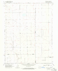
1968 Map of Towner SE
USGS Topo · Published 1971About this map
Wild Horse Creek meanders through this high-plains landscape, cutting a distinct drainage path across a region otherwise marked by subtle topography and scattered water Wells. This 1968 survey illustrates the vast, open character of the borderlands where Colorado meets Kansas. Land usage is defined by large-scale tracts such as Richland and Colony, while infrastructure is limited to a diagonal Pipeline and a few local landmarks like the elevated point known as Bones. The map captures the intersection of five counties, including Kiowa, Prowers, and Greeley, highlighting a remote agricultural and resource-gathering era evidenced by a solitary Gravel Pit. It is a precise record of the geometric survey lines that partitioned the western prairie into managed townships and sections.
Find a feature on this map
12 named features on this map. Tap any name to fly to it.
Don’t see what you’re looking for? This feature index may not catch every label — zoom into the map to look around manually.
Map Details
Editions of this 1968 Towner SE Map
This is the sole edition of this map. No revisions or reprints were ever made.
Other maps of this area

1890 · Granada
USGS Topo · 1:125,000

1892 · Granada
USGS Topo · 1:125,000

1894 · Granada
USGS Topo · 1:125,000

1954 · Lamar
USGS Topo · 1:250,000

1955 · Holly NE
USGS Topo · 1:24,000
1955 · Holly NW
USGS Topo · 1:24,000

1955 · Scott City
USGS Topo · 1:250,000

1958 · Lamar
USGS Topo · 1:250,000

1958 · Scott City
USGS Topo · 1:250,000
1966 · Tribune 3 NW
USGS Topo · 1:24,000