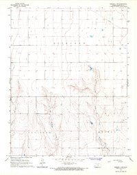
1966 Map of Tribune 3 NW
USGS Topo · Published 1967About this map
Richland and Coolidge townships in Hamilton County are defined by a high plains landscape marked by seasonal drainage and industrial development. In the mid-1960s, the terrain was shaped by the presence of the Amity Canal (Abandoned), reflecting earlier irrigation efforts that had given way to other land uses. The southern portion of the map is dissected by Spring Creek, West Bridge Creek, and East Bridge Creek, where the topography becomes significantly more complex with deep draws and ridges. A Ford provides a rare crossing point over West Bridge Creek, indicating local transportation routes through the more difficult terrain. Energy exploration is prominent in the eastern sections, evidenced by several Gas Wells, a Drill Hole, and a prominent Pipeline cutting across the northern reaches of the quadrangle.
Find a feature on this map
17 named features on this map. Tap any name to fly to it.
Don’t see what you’re looking for? This feature index may not catch every label — zoom into the map to look around manually.
Map Details
Editions of this 1966 Tribune 3 NW Map
2 editions found
Other maps of this area

1890 · Granada
USGS Topo · 1:125,000

1892 · Granada
USGS Topo · 1:125,000

1894 · Granada
USGS Topo · 1:125,000

1953 · Holly East
USGS Topo · 1:24,000

1954 · Lamar
USGS Topo · 1:250,000

1955 · Holly NE
USGS Topo · 1:24,000

1955 · Scott City
USGS Topo · 1:250,000

1958 · Lamar
USGS Topo · 1:250,000

1958 · Scott City
USGS Topo · 1:250,000
1966 · Tribune 3 SW
USGS Topo · 1:24,000