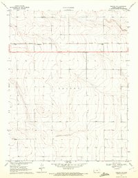
1970 Map of Tribune NW
USGS Topo · Published 1972About this map
The high plains of Greeley County are defined here by a sparse landscape of remote rail sidings and rural cemetery plots. The Missouri Pacific railroad cuts a straight line across the northern portion of the map, serving as the lifeline for small whistle-stops like Walkinghood and Astor. These small clusters of structures represent the intersection of transportation and agricultural utility in this western Kansas region. Local history is anchored by the presence of Rogers Cem to the north and Mathews Cem further south, marking the final resting places of early homesteaders in the Colony area. Outside of these markers and a roadside Picnic Area along Route 96, the terrain remains dominated by the broad, open stretches characteristic of the High Plains.
Find a feature on this map
10 named features on this map. Tap any name to fly to it.
Don’t see what you’re looking for? This feature index may not catch every label — zoom into the map to look around manually.
Map Details
Editions of this 1970 Tribune NW Map
This is the sole edition of this map. No revisions or reprints were ever made.
Other maps of this area

1890 · Granada
USGS Topo · 1:125,000

1892 · Cheyenne Wells
USGS Topo · 1:125,000

1892 · Granada
USGS Topo · 1:125,000

1894 · Cheyenne Wells
USGS Topo · 1:125,000

1894 · Granada
USGS Topo · 1:125,000

1954 · Lamar
USGS Topo · 1:250,000

1955 · Scott City
USGS Topo · 1:250,000

1958 · Lamar
USGS Topo · 1:250,000

1958 · Scott City
USGS Topo · 1:250,000
1968 · Towner SE
USGS Topo · 1:24,000
Featured Places
- Astor, Tribune Township
- Walkinghood, Tribune Township
- Tribune Township, KS
- Greeley County, KS
- United States