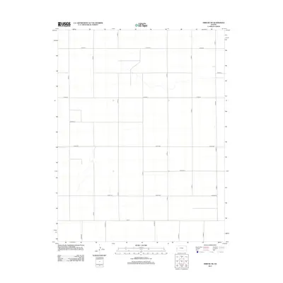
2012 Map of Tribune SW
USGS Topo · Published 2012About this map
Tribune Township in southwest Kansas is characterized by a precise, orthogonal grid of rural transportation routes that define its agricultural character. The landscape is segmented by an extensive network of county roads, including the east-west corridors of Co Road X, Co Road Z, and Co Road BB. These paths provide the primary structure for the region's land management and farming operations, typical of the High Plains where surveyors carved the territory into repeatable sections. North-south routes such as Co Rd-5 and Co Rd-8 intersect this grid, facilitating movement across the open terrain. This 2012 survey documents a sparsely settled area where the geometric organization of the land remains its most prominent feature, reflecting the enduring legacy of the Public Land Survey System in defining the rural American West.
Find a feature on this map
20 named features on this map. Tap any name to fly to it.
Don’t see what you’re looking for? This feature index may not catch every label — zoom into the map to look around manually.
Map Details
Editions of this 2012 Tribune SW Map
This is the sole edition of this map. No revisions or reprints were ever made.
Other maps of this area

1890 · Granada
USGS Topo · 1:125,000

1892 · Granada
USGS Topo · 1:125,000

1894 · Granada
USGS Topo · 1:125,000

1954 · Lamar
USGS Topo · 1:250,000

1955 · Holly NE
USGS Topo · 1:24,000

1955 · Scott City
USGS Topo · 1:250,000

1958 · Lamar
USGS Topo · 1:250,000

1958 · Scott City
USGS Topo · 1:250,000
1966 · Tribune 3 NE
USGS Topo · 1:24,000
1966 · Tribune 3 NW
USGS Topo · 1:24,000