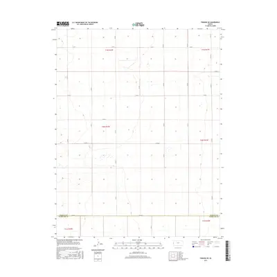
2015 Map of Tribune SW
USGS Topo · Published 2015About this map
The high plains along the border of Greeley County and Hamilton County are defined by a precision grid of section lines and rural thoroughfares. This 2015 survey reveals the characteristic agricultural land management of Western Kansas, where the terrain is traversed by a series of alphabetically designated routes. Major east-west arteries like Co Rd X, Co Rd Z, and Co Rd Ee organize the vast open spaces of Township 19 South and Township 20 South. The map provides clear evidence of the Public Land Survey System, illustrating how township and range divisions such as t20s r42w create the geometric landscape typical of the region. This documentation is essential for researchers looking to pinpoint specific land parcels or historical property boundaries within this sparsely populated rural corridor.
Find a feature on this map
13 named features on this map. Tap any name to fly to it.
Don’t see what you’re looking for? This feature index may not catch every label — zoom into the map to look around manually.
Map Details
Editions of this 2015 Tribune SW Map
This is the sole edition of this map. No revisions or reprints were ever made.
Other maps of this area

1890 · Granada
USGS Topo · 1:125,000

1892 · Granada
USGS Topo · 1:125,000

1894 · Granada
USGS Topo · 1:125,000

1954 · Lamar
USGS Topo · 1:250,000

1955 · Holly NE
USGS Topo · 1:24,000

1955 · Scott City
USGS Topo · 1:250,000

1958 · Lamar
USGS Topo · 1:250,000

1958 · Scott City
USGS Topo · 1:250,000
1966 · Tribune 3 NE
USGS Topo · 1:24,000
1966 · Tribune 3 NW
USGS Topo · 1:24,000