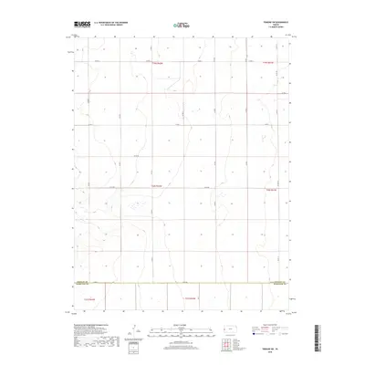
2018 Map of Tribune SW
USGS Topo · Published 2018About this map
Greeley County meets Hamilton County in this western Kansas landscape defined by the rigid geometry of the Public Land Survey System. The map documents a sparsely populated agricultural region during the early twenty-first century, where the terrain is segmented into precise sections by an extensive grid of local roads. These essential conduits, such as Co Rd BB and Co Rd X, follow township and range lines, providing the primary infrastructure for the high plains farmsteads and fields. The sparse hydrography and uniform distribution of thoroughfares like Co Rd 5 and Co Rd 10 illustrate the systematic organization of the frontier long after its initial settlement, preserving the 19th-century surveying legacy in a modern digital format.
Find a feature on this map
21 named features on this map. Tap any name to fly to it.
Don’t see what you’re looking for? This feature index may not catch every label — zoom into the map to look around manually.
Map Details
Editions of this 2018 Tribune SW Map
This is the sole edition of this map. No revisions or reprints were ever made.
Other maps of this area

1890 · Granada
USGS Topo · 1:125,000

1892 · Granada
USGS Topo · 1:125,000

1894 · Granada
USGS Topo · 1:125,000

1954 · Lamar
USGS Topo · 1:250,000

1955 · Holly NE
USGS Topo · 1:24,000

1955 · Scott City
USGS Topo · 1:250,000

1958 · Lamar
USGS Topo · 1:250,000

1958 · Scott City
USGS Topo · 1:250,000
1966 · Tribune 3 NE
USGS Topo · 1:24,000
1966 · Tribune 3 NW
USGS Topo · 1:24,000