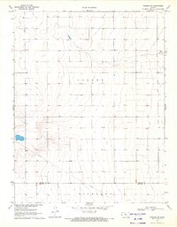
1970 Map of Tribune SW
USGS Topo · Published 1972About this map
Colony and Richland townships define the landscape of the High Plains in this 1970 survey. The map records a sparsely settled agricultural region near the Kansas-Colorado border, where the land is strictly organized by the township and range grid system. A notable aviation landmark, the Tuttle Landing Field, is situated in the northeastern corner of the quadrangle, serving as a remote waypoint for rural pilots. The southern portion of the sheet is bisected by a significant Pipeline, an industrial addition to the prairie that cuts diagonally across the section lines. This document captures the transition between Greeley Co and Hamilton Co, documenting the subtle topography of the Great Plains before modern large-scale irrigation and development further altered the drainage patterns and land use of the region.
Find a feature on this map
5 named features on this map. Tap any name to fly to it.
Don’t see what you’re looking for? This feature index may not catch every label — zoom into the map to look around manually.
Map Details
Editions of this 1970 Tribune SW Map
This is the sole edition of this map. No revisions or reprints were ever made.
Other maps of this area

1890 · Granada
USGS Topo · 1:125,000

1892 · Granada
USGS Topo · 1:125,000

1894 · Granada
USGS Topo · 1:125,000

1954 · Lamar
USGS Topo · 1:250,000

1955 · Holly NE
USGS Topo · 1:24,000

1955 · Scott City
USGS Topo · 1:250,000

1958 · Lamar
USGS Topo · 1:250,000

1958 · Scott City
USGS Topo · 1:250,000
1966 · Tribune 3 NE
USGS Topo · 1:24,000
1966 · Tribune 3 NW
USGS Topo · 1:24,000