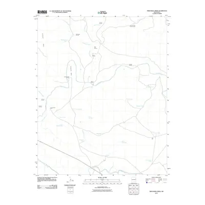
2010 Map of Trinchera Creek
USGS Topo · Published 2010About this map
The Canadian River cuts through this arid San Miguel County landscape, defining the local geography through significant features like the dramatic Horseshoe Bend. Ranching infrastructure dominates the high ground, with numerous water management points such as Trinchera Tank and Loma Cita Tank supporting the region's cattle operations. The presence of the Conchas Canal in the southern portion of the quadrangle highlights the critical role of water diversion in this high-desert environment.
Find a feature on this map
38 named features on this map. Tap any name to fly to it.
Don’t see what you’re looking for? This feature index may not catch every label — zoom into the map to look around manually.
Map Details
Editions of this 2010 Trinchera Creek Map
This is the sole edition of this map. No revisions or reprints were ever made.
Other maps of this area

1930 · Tucumcari
USGS Topo · 1:125,000

1954 · Tucumcari
USGS Topo · 1:250,000

1958 · Tucumcari
USGS Topo · 1:250,000

1967 · Trinchera Creek
USGS Topo · 1:24,000

1967 · Liberty Mesa
USGS Topo · 1:24,000

1967 · Tucumcari
USGS Topo · 1:24,000

1968 · Bascom Camp
USGS Topo · 1:24,000

1968 · Hampton Ranch
USGS Topo · 1:24,000

1968 · Carpenter Mesa SW
USGS Topo · 1:24,000
1968 · Cow Canyon
USGS Topo · 1:24,000